
Random Fantasy Maps #4 - Town of Frattisham

Hello and welcome back to the Random Fantasy Maps series, where we will be exploring fantasy map creation from different eras. In this post, I am going to be exploring the process of creating the small town of Frattisham, from which the design is inspired from one of the 25-inch Ordnance Survey 19th century maps. 

While this map isn't exactly going to be 25 inches in size due to the constraints that are associated with drawing in an A3 sketchbook, I hope you will find this tutorial useful for producing a historical map in any case!

What is the town of Frattisham?

Please note that this section was written from a late-19th to early 20th century perspective, so that it is in line with the dates that the old Ordnance Survey maps were published in.

Frattisham is a village that has a population of 674 people as of the 1881 census. It was founded in 1763, with the castle being built not long after in 1778, and would subsequently be used as a strategic vantage point in the Battle of Frattisham that took place in 1826.

Located towards the north of the historical centre is St Mary's Church, which is a Roman Catholic church that was built in 1764 and is approximately 25 metres (83ft) tall up to the pinnacles of the church and is one of the most well-known examples of architecture that has been preserved since the 1826 war. 

The railway line to Frattisham was opened in 1857 to bring prosperity to the village by providing easier access for goods into the village and improving economic mobility for the residents by cutting down prices in the local shops. The line was eventually brought into passenger service by 1866, with the station serving approximately 80,000 people per year.

There are two schools servicing Frattisham - the local primary school, located along Walter Lane in the east of the village, houses around 120 children from the ages of 4 to 11 who live in the town as well as in the surrounding villages, while 470 students between the ages of 11 and 16, who also come from places located up to 25 miles away from the village, attend the high school located along Humber Doucy Lane in the south. 

In terms of local employment opportunities, the Frattisham Brewery, located in Brewery Lane, was opened in 1871, and produces approximately 1.3 million hectalitres of beer a year with the help of approximately 150 workers. The brewery is closely connected to the malthouse located on the other side of the village in Walter Lane, which is used for converting grain into malt before the beer can be further distilled at the brewery.

There is no large conglomerate trade in the village (so no McD's or Tescos for that matter), so the independent shops located in the historical centre of the village primarily sell artwork originating from famous artists, as well as wood carvings and vintage clothes.

Process of building the map

As previously explained in the blog post where I went for volunteer training at the Archives, there is a huge collection of historic maps at the local records office where I live, but the Suffolk Archives library at the Hold is not always open and you don't always want to have physical maps lying around you when you are drawing with a sketchbook - it would be a real mess! So to remove the limits on how I am able to gain inspiration, I decided to go onto the National Library of Scotland website, where they host some old-style Ordnance Survey maps from the 19th and early 20th centuries.

On their website, I selected the link to the 25-inch Ordnance Survey maps of England and Wales, as shown here:


I felt that the map of Eye (36/3) that I went through at the Archives training would be a really good map to gain some inspiration from due to the diverse mix of urban and rural areas that are illustrated in that map. So I zoomed in to the area around Eye, and clicked on the square representing the area around Eye as illustrated here:


There is even the option to zoom the map in - perfect for getting in that extra detail with buildings when drawing the map later!

25-inch Ordnance Survey map of Eye, Suffolk (credit given to the National Library of Scotland)

Now that I have some inspiration in terms of how I am going to make this map, it's time to get to the drawing. From there, I decided to start the hand-drawn design of the map, firstly beginning with the streets, before moving on to the buildings and labelling the most important sites. Here is what the map looks like after the process:

Once the streets and buildings were drawn, I then decided to do some more touching up of the map by adding the street names and the name of the settlement that we are working on which returns this result from the drawing here:

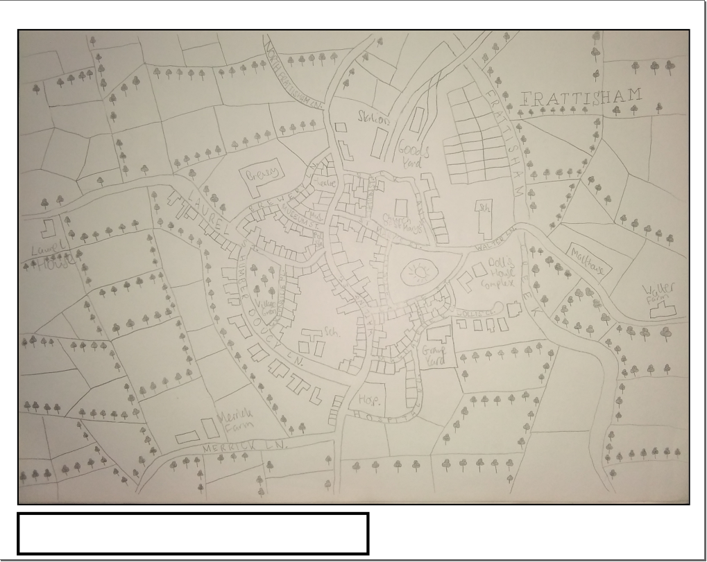
With the street names now added to the map, it was now time to do some illustrations for plots of land and trees! The following image below shows the final result for the hand-drawn map of the settlement of Frattisham:


With that all done, it is time to get to drawing the map using the trusty Inkscape tool! Firstly, let's get the overlay set-up so that we know where to set up the frame where the map will be drawn, by doing some cropping of the sketchbook binder and areas of the image that don't show in the map, returning the result shown here:

Then, once the overlay has been inserted, what we are going to do next is adjust the size of the page in the document settings, so that there is space to insert the border and map legends. In this case, we are using the page size of around 2175x1730, as seen here:

With  the properties now set, it was time to get round to drawing the frames, with the map legend on the bottom, and some information on the map on the bottom right corner:


Now that the basic map layout has been organised, it is now time to get to drawing the map digitally, firstly starting with drawing the roads. Given that the historic Ordnance Survey maps were produced in black and white, the choice of the colour scheme here is deliberate so to give the feel of it being a historical map. 

That being said, the black and white nature of the map means that I have to change the process of making the map from the Somerville project - in that project I could just draw a simple stroke line and connect it up to a different street, whereas here I need double-stroke lines, for which there is no specific tool to do that directly in Inkscape.

And so after a bit of googling around to find the best solution to this problem, I've managed to come up with a workaround to this - I started off by drawing simple stroke lines (making sure that there are nodes at the points where I want to connect up the streets), then combining all the street lines together, before going on to follow the "Stroke to Path" technique, followed by "Union" to split the lines apart and then adjusting the stroke fill and size. 

Drawing Dollis Close was the most difficult part of this stage of the project due to its cul-de-sac nature, so I had to play around with that street so that I can get it to look like a cul-de-sac, as seen here:


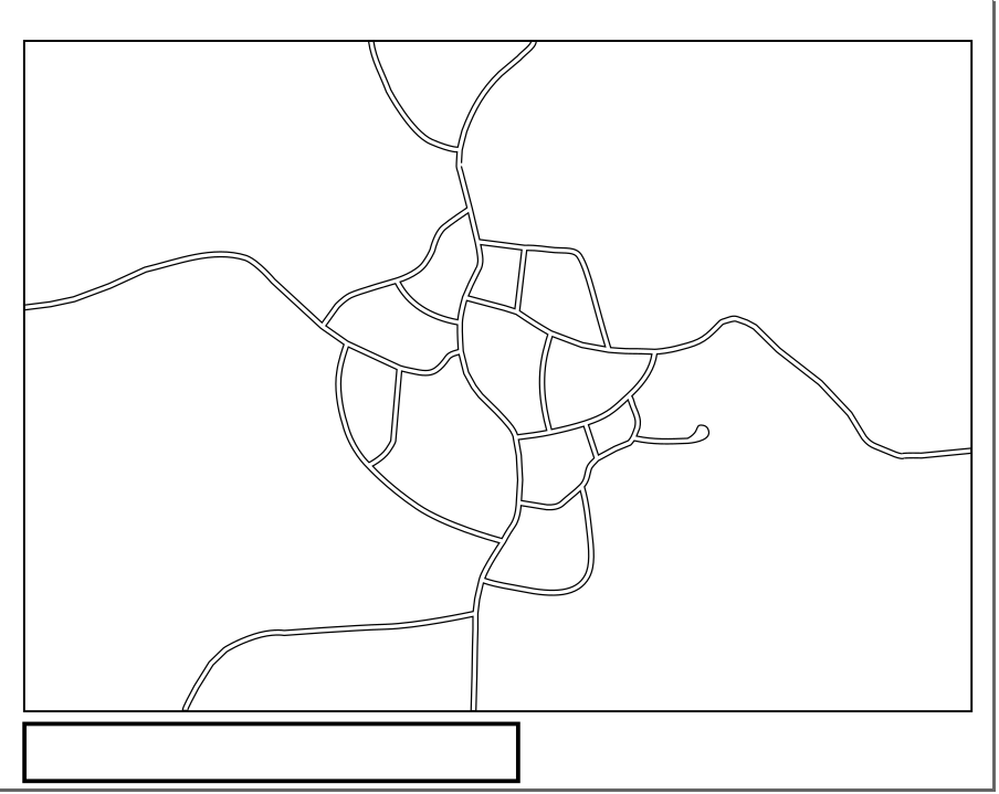
And after spending some time drawing the streets and adjusting them, here is the end result from that stage of the design (shown without the overlay):


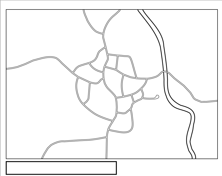
The next step was to add in Frattisham Creek to the east of the village using the same technique as the previous step, as well as deleting some line segments that overlap with the Walter Lane bridge crossing, to generate this output (again, shown without the overlay):


With that done, it was now time to get onto the most relaxing part of making the map - drawing the parcels of land that surround Frattisham. This time, there was no need to play around with stroke to path and draw a double stroke line, as the land parcels on the original Ordnance Survey map were displayed as a single line. 

For the land parcel lines, I decided to apply a stroke width of 0.365mm, generating this output here:

The following output shows how big of a time saver using a hand-drawn overlay can be to draw different elements of the map - it only took me about three hours to draw up all of the land parcels, whereas with the Somerville project, it would have taken me multiple days to guess the locations of the streets and get them drawn. Here is what the map looks like after drawing the land parcels:


That being said, it is now time to start the most "fun" part of the project - drawing the buildings! It hasn't been easy drawing the buildings due to the street lines not being quite wide as the hand-drawn version in some places, and there have been some occasions where I have had to change the width of some of the streets to make sure that I get the best possible scale from those buildings.

After spending about seven hours on the buildings, this is what the map looks like without the overlay:

And with that, it was now time to draw the railway lines leading into Frattisham. For this, I decided to narrow down the stroke width of the line representing the tracks to approximately 1.5mm, before applying the Stroke to Path tool to create a double stroke effect and then setting the line width to 0.200mm. Then I broke apart the lines representing Frattisham Creek so that a bridge over the creek can be drawn, which in turn leads to this result here:


With the railway lines now drawn, this is what the town of Frattisham looks like at this point in the project:


And so it was now time to move on to the final step of the core map design, which is to decorate the map with trees. To speed up the process, I have decided to take the tree graphics from the original OS map that I found on the NLS website, recreate the tree graphics in a separate file... 


...save the graphic as a 32x32 PNG and then copy and paste them into the main map design, as illustrated here:


And then we do it enough times until we get this result:


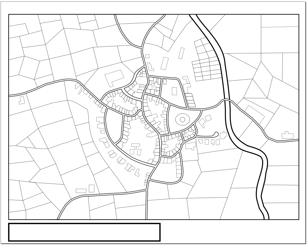
With the trees now added to the map, it was now time to apply some final touches on the map by labelling the streets, adding the town name and map legends - which involved having to do a bit of rotating, creating curved text styles and other whatnots. And with that, here is the final map of Frattisham (feel free to click on the image for the full size):


Conclusions from the Frattisham Project
I have to say that I have had a really good time working on the project overall - for me, drawing historic Ordnance Survey recreations has to be my second favourite kind of fantasy map that I would like to draw after modern fantasy, and there are some elements of the project that make you want to relax - such as drawing the lines representing land parcels and adding in the trees to the map. At the end of the day, I do think that there is a lot of potential for people to come along and make recreations of historical maps!

To be quite honest, I can safely say that working on this project has thrown in some very steep learning curves in terms of learning the more advanced features of Inkscape, as I have managed to overcome the limitations of the program by using the "Stroke by Path" tool to get a double stroke to draw black and white streets, as well as by learning how to use the "Path Effects" tool to create curved text patterns (as seen in the example of me illustrating the path of the Frattisham railway line). I don't think that this project would have been possible for me to accomplish without the help and expertise of other people that have posted material on Inkscape online.

I do however think that I could have improved the map design by adding a grey fill to the buildings, as well as adding some white to grey gradients around the moat area of the castle to mark the drastic change in height. That way, it would have improved the overall aesthetics of the map and brought the design closer in line to the original Ordnance Survey maps from the early 20th century.

Moving on to the size and how the well the map is projected when it is printed out, I believe that this map is better intended for display on larger paper (A3 and larger) due to the small text size and the large resolution in which the map was originally created - although when I printed the map out in A4, the text for the street names is just about readable if you study it very closely. But printing the map for it to go into smaller picture frames? Unless the street names or the map legend is left out of the map, no thanks. 

That being said, I hope you have enjoyed this post on how I made the map of the village of Frattisham, and I shall see you on the next blogpost, which will provide a round-up of the things that I have experienced in real-life in the lead-up to Christmas (including a summary of the pitching event that the future Bootcampers took part in, going to the British Library to watch some fantasy talk, and much more!). 

But in terms of what will be coming up in this series of blogposts, the next random fantasy map that I am going to show off on this blog will be the Ptolemy-inspired map of the country of Ternia - something even older than the map that I have been working with just now. Should be plenty of fun to show off once that's finished!

Signing off now,

Jakub

Comments

Popular posts from this blog

My experience at the Make a Difference Boot Camp - The Grand Finale

Well, here it is everybody - the final installment of the Make a Difference Boot Camp series!  The Volkert has returned to bring life back to the Bootcamp after the theory labyrinth of Days 6 and 7, and we're going to take you through the journey of preparing and practicing the pitch, and then presenting it to a crowd of judges and guests as part of the Grand Finale. Plus, tons of intense action (of different sorts) along the way! If you are new to reading the Make a Difference series and you aren't yet familiar with the events that led up to the Grand Finale, I would like to invite you to take a look at the previous posts that I have made on the Make a Difference Boot Camp: Days 1 to 3 ; Days 4 and 5 ; as well as Days 6 and 7 . Have I won the £2000 share of the prize money? Find out later in this post! Day 8 - 30th of June 2023 The day started off with a change of geographic scenery this time - unlike previous days where I was waiting outside the Atrium building waiting to be

Exploring the zen atmosphere of Slowroads.io

I would like to use this blog post to explore something that is slightly different to fantasy map creation, but still blends in nicely with the theme of this blog by providing a review of wellness-related products in the virtual gaming world. For those who are unfamiliar with the site, Slowroads.io is a web-based driving simulator made by Anslo that aims to provide a relaxing driving experience, and it uses some interesting software engineering quirks, such as using AI to generate a continuous set of landscapes. Slowroads offers two maps, the "Hills" map (which is fictional, but takes inspiration from the landscapes seen in the north of England) and the "Off World" map (based on Mars), however, for the purposes of this post, I will be using the "Hills" map to review the simulator since the user experience with both maps is fairly similar.  Upon accessing the landing page for the simulator, the one thing that I was fascinated about with respect to the look

My experience at the Make a Difference Boot Camp - Days 1 to 3

Let's start this post by telling you that this is a completely different post to what I usually make on this blog. Over the past couple of months, I have been using my blog to discuss my fantasy map projects and the things that make me feel passionate about cartography, as part of a plan to create a business idea out of it. Thus, I have been involved over the last week in a social enterprise programme, and I would like to share the experiences of my time there. The "Make a Difference Boot Camp" is a social enterprise programme that is run jointly by the Enterprise and Entrepreneurship team at the University of Suffolk (with the event managed from that side by Amy Volkert ) and Dot-to-Dot Consultancy , a consultancy firm helping people build social enterprise business ideas. It is set to take place over nine days in the months of June and July, with the programme culminating with a pitching event on the 7th of July. Make a Difference Boot Camp Schedule (Credit to Universit